Tag: biodiversity

  • In carbon sequestration, money grows on trees

    In carbon sequestration, money grows on trees

    Guyana’s tropical rainforests protected under the REDD program provide not just natural resources but an income stream to the country.
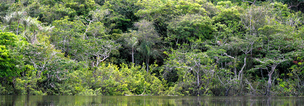
    Two hours south of Georgetown, Guyana, a paved highway recedes, giving way to a rutted red road gushing through thick rainforest. In its muddiest spots, the road swallows trucks and spits them out at dangerous angles. Many hours later, it leads to an area of protected land called Iwokrama, a Rhode Island-size forest in the heart of Guyana, crowded with ancient buttress-trunked trees draped in liana vines.

    [media-credit name=”Hannah Hoag” align=”alignleft” width=”300″]red-mud-guyana[/media-credit]Since 2003, Jake Bicknell has been a fixture within this forest. Now a doctoral student in biodiversity management at the U.K.’s University of Kent, he is cataloging Iwokrama’s iconic and bizarre species, including jaguars, giant anteaters, anacondas, and scads of birds and bats. (Guyana boasts more than 700 bird and 120 bat species.)

    Specifically, he’s in Iwokrama to find out how logging affects tropical forest wildlife. Conventional logging ruins forests and decimates species, but low-impact methods of harvesting timber might not be so damaging. In fact, Bicknell believes selective logging can become a tool for protecting the forests and biodiversity of Guyana — a developing country eager to tap its natural resources as a way to boost its economy.

    “There will always be a market for products extracted from forests, so the point is to do it in the least impacting way,” says Bicknell.

    Keep reading this story in the November 2013 issue of Discover

  • Bats before bedtime

    Bats before bedtime

    Scientists find new animal species in old rainforests

    Deep in the heart of a small South American country called Guyana lies a protected forest. As night falls, you will find this tropical rainforest pulses with life. It is anything but quiet. The whistle of a bird called the screaming piha pierces the thick canopy of trees, as if competing with the chorus of crickets, cicadas and mosquitoes. Other strange creatures make themselves heard too. A sheep frog bleats while red howler monkeys spookily wail from the treetops. On this evening, it seems no one in the rainforest is sleeping — including the scientist making his way down a narrow path.

    Night is a great time to collect animals. To catch flying bats, it is also the only time. That is why Burton Lim is at work in the dark here in this forested region known as Iwokrama (EE WOE kram ah). It’s part of the greater Amazon ecosystem.

    Some people call Lim the Bat Man. He’s a curator of mammals at the Royal Ontario Museum, in Toronto, Canada. Tonight, he forges into the dark rainforest to look for bats. He’s wearing a bright headlamp and rubber boots. A machete hangs from his belt.

    Lim has come to the Iwokrama Forest because it is a hotspot for bats. Eighty-six species of them, roughly half of all the bats found across the Amazon, call this roughly circular zone of protected land home. The area is only about the size of Delaware. By comparison, the United States and Canada together host only 47 bat species.

    A region called the Guiana Shield includes the South American countries of Guyana, Suriname, French Guyana and parts of Venezuela, Brazil and Colombia. Much of the tropical rainforest in this area is undisturbed. Credit: Shadowxfox, Wikimedia Commons

    Lim is on this expedition with a small team of scientists working with a conservation organization called Operation Wallacea. They’re here to study the rainforest’s large mammals, amphibians, birds, insects, reptiles and other animals. Luckily, a reporter for Science News for Kids is tagging along for part of the expedition. Exploring this richness of life, or biodiversity, lets scientists pinpoint areas that have rare or unique species. It also gives them clues useful in monitoring the health of this rainforest now — and in the future.

    Continue reading this story at Science News for Kids.

  • Scientists call for no-fishing zone in Arctic

    Scientists call for no-fishing zone in Arctic

    Nature

    Thousands of scientists from 67 countries have called for an international agreement to close the Arctic high seas to commercial fishing until research reveals more about the freshly exposed waters.

    Recent Arctic sea-ice retreat during the summer months has opened up some of the waters that fall outside of the exclusive economic zones of the nations that circle the polar ocean. In all, more than 2.8 million square kilometres make up these international waters, which some scientists say could be ice free during summer months within 10–15 years. Although industrial fishing hasn’t yet occurred in the northernmost part of the Arctic, the lack of regulation may make it an appealing target for international commercial-fishing vessels.

    “The science community currently does not have sufficient biological information to understand the presence, abundance, structure, movements, and health of fish stocks and the role they play in the broader ecosystem of the central Arctic Ocean,” says the letter, which was released by the Pew Environment Group on Sunday on the eve of the opening of the International Polar Year 2012 scientific conference in Montreal, Canada. More than 2,000 scientists, including 1,328 from Arctic coastal countries, signed the letter.

    The letter calls for the Arctic countries to put a moratorium on commercial fishing in the region until the impacts of fisheries on the central Arctic ecosystem, including seals, whales and polar bears, and those who live in the Arctic, can be evaluated.

    In 2009, the United States adopted a precautionary approach by banning commercial fishing in the waters north of the Bering Strait, including the Chukchi and the Beaufort Seas. The Arctic Fishery Management Plan closes nearly 400,000 square kilometres to commercial fishing. Canada is drafting its own fisheries policy for the adjacent Beaufort Sea. In 2011, a memorandum of understanding between the Canadian federal government and the Inuvialuit people of the western Arctic prohibited the issuing of new commercial fishing licences in the area until a management plan was created and put into practice.

    “Our knowledge of Canadian marine biodiversity is next to nil. We know nothing about trends over time for a single marine fish in the Arctic,” says Jeffrey Hutchings, a biologist at Dalhousie University in Halifax, Nova Scotia. Hutchings says that scientists have pushed for such measures before, adding that it is up to the Arctic nations to implement such measures through the Arctic Council. “The Canadian government seems unwilling to take a stand similar to that of the US.”

    This story originally appeared on the Nature News blog.

    Photo: Jessica K. Robertson/ US Geological Survey

  • Mixed Reviews for Quebec’s Plan Nord

    Mixed Reviews for Quebec’s Plan Nord

    The government of Quebec (Canada) has launched its multibillion-dollar Plan Nord, which will open the vast northern reaches of the province to mining and energy development–and protect 50% of the territory from economic development.

    The 1.2-million-square-kilometre region—twice the size of France—is known for its wild rivers, biodiversity, diverse ecosystems and a large swath (about 20%) of Canada’s boreal forest. Boreal forest covers more than 25% of Quebec. More than 120,000 people, including 33,000 aboriginals also live in the region.

    Quebec Premier Jean Charest said yesterday the government will invest CDN$80 billion into mining, forestry, transportation, energy development and tourism over the next 25 years.

    The environmental aspects of the plan include the promise to set aside 600,000 square kilometres of the region to protect the environment and preserve biodiversity. By 2016, the government will have established several provincial parks, completed a survey of northern Quebec’s biodiversity, protected over 31,000 square kilometres of land, and adopted mitigation or restoration plans for each development project.

    By protecting half of the forest, the Quebec government will keep more than 13.8 billion tons of CO2 sequestered—equivalent to about 70 years of industrial carbon dioxide emissions in Canada (Canadian Boreal Initiative, 2009 release).

    The Plan Nord is getting mixed reviews from environmental groups. The Canadian Boreal Initiative, affiliated with the Pew Environment Group’s International Boreal Conservation Campaign applauded the sustainable development measures included within the plan (release). But others, including Greenpeace and Nature Quebec, said they could not endorse the plan as presented. The coalition of groups told the Globe and Mail the plan was “an attempt to regulate a mining boom rather than the expression of an authentic vision for the north.” They called for, among other things, an evaluation of the global environmental impacts of northern development.

    From the Nature News blog.

    Image: MRNF, Gouvernement du Quebec

  • Banking on biodiversity

    Banking on biodiversity

    The diversity of life on Earth gives ecosystems the resilience they need to thrive. Yet every day scores of plants and animals go extinct, victims of activities we humans undertake to feed, clothe, house and trans­port ourselves. How can we meet our own needs without destroying that which sustains us?

    The west coast of Vancouver Island in British Columbia, Canada, has a rugged, involuted shoreline, etched by fjords, sand dunes and shel­tered coves. It is sandwiched between two biospheres, the dark swelling sea and the emerald temperate rain forest, and it attracts all sorts—from salmon to surfers.

    As idyllic as it seems, the island is under pressure. Wild salmon populations seem to ebb and flow unpredictably, and logging, transporta­tion and aquaculture—activities that promise economic prosperity for the people who live here—are chipping away at the natural coastal ecosystem and the species it contains.

    The tug-of-war between opposing priorities—the conservation of natural assets and de­velopment—poses a challenge for West Coast Aquatic, the public-private partnership in charge of creating a marine spatial plan for the 285-mile-long shoreline. How to lay out a plan that allows the area to develop while preserving its natural resources, ecosystems and habitat?

    This balance of development and conservation is a challenge wherever people are found. At its core is the ability to understand and factor in the true impact—economic and otherwise—of human activity, whether it’s shipping, aquaculture or recreation, on the environment. Would con­struction of an offshore wave energy installation cut into revenues brought in by recreation? If so, by how much? Is it worth it? What effect would expansion of aquaculture have on native finfish and shellfish? At what price to ecosystem (and economic) integrity?

    For West Coast Aquatic, the answers may come from “SimCity”-like software that can illustrate the impacts of different scenarios on human well-being and biodiversity.

    Called Marine InVEST, the software considers a region’s underwater topography, native habitats, species distribution, fishing practices, aquaculture sites, coastline features (such as dunes and sea grasses), wave height and periodicity, and recreational activities. Once those data have been collected, Marine InVEST can calculate the outcomes of a variety of scenarios, such as establishing a protective area or shellfish aquaculture sites.

    “The tool is flexible in terms of outputs, whether it’s in meters of shoreline not eroded or pounds or number of fish—or dollars,” says Anne Guerry, lead scientist for the project’s marine initiative.

    The west coast of Vancouver Island is the first demonstration site of Marine InVEST by the Natural Capital Project, a partnership among Stanford University, The Nature Conservancy, World Wildlife Fund, and the University of Minnesota’s Institute on the Environment.

    “In the past, we didn’t think too much about the spatial overlap of marine activities. We tended to think of them in silos,” says Guerry. “A tool like Marine InVEST allows us to make clear connections between different activities, so we can understand and value each one and how emphasizing one can come at the cost of another.”

    The group plans to use Marine InVEST in other demonstration sites around the world, including Belize, Puget Sound, Chesapeake Bay and Galveston Bay.

    Already, governments, nongovernmental organizations and scientists at universities and institutes in Indonesia, Hawaii, Tanzania, Colom­bia, Ecuador and China are adopting InVEST, the Natural Capital Project’s land-focused companion to Marine InVEST, in their decision making. In the East Cauca Valley, Colombia, The Nature Conservancy and ASOCAÑA, an association of sugarcane producers, formed a water fund called Fondo de Agua por la Vida y la Sostenibilidad (Water Fund for Life and Sustainability) to invest in key areas to keep the water sediment-free and available. The group then used InVEST to map carbon storage, habitat quality and soil stabiliza­tion within the region—showing, for example, where the group should invest in reforestation or in fencing off an area, while taking into account the communities that live within the watersheds.

    “Spatial mapping [like InVEST] lets us map out impacts, letting stakeholders better view and understand impacts and trade-offs,” says Ken Bag­stad, a postdoctoral associate at the University of Vermont. Bagstad is applying InVEST models for water, carbon, biodiversity and cultural services to the exceptionally biodiverse San Pedro River watershed in southeastern Arizona. Home to one of the last free-flowing rivers in the Southwest and a key bird migration corridor, the region is struggling to balance the water needs of the com­munity with the riverbank ecosystem. Bagstad is using InVEST and another mapping tool, ARIES, to test several scenarios, including an option that would restore an invasive mesquite shrubland to native grasslands. The main challenge of using such tools, says Bagstad, is that they are still in their infancy and require some more work before they can be considered a generalized global tool.

    The Planet’s Heartbeat

    Biodiversity is the measure of the variety of life. It is the seed from which all ecosystems spring. It is the foundation of the wetlands that purify water and offer protection against floods, the forests that capture carbon dioxide from the atmosphere and store it in biomass, and the coral reefs that offer breeding grounds for fish. Biodiversity provides societies with goods—food, fuel, fiber and medicinal plants—and services—erosion control, hydropower, cultural significance, recreation, carbon sequestration. Clean air, Vermont maple syrup, opportunities to ice fish, plant-sustaining soil and much more all trace back to thriving living things. Each species is like a spot of paint in one of Seurat’s pointillist masterpieces—an element of the whole picture.

    Environmentalists Tina Fujikawa and Joseph Dougherty recently wrote, “Monitoring trends in biodiversity is like listening to the heartbeat of the planet.” If so, the planet’s pulse is weak and sluggish. Many of Earth’s mammal, bird and amphibian species—10 to 30 percent—are threatened with extinction due to human activities. Some, like corals, which have long been identified as extinction risks, are moving closer to extinction, and ecosystems continue to deteriorate and be splintered apart. Scientists say that if current trends endure, societies could suffer heavy consequences.

    In a 2009 article in Nature, an international group of scientists and economists led by Johan Rockström of the Stockholm Resilience Centre at Stockholm University identified and quantified nine planetary boundaries—from climate change and ocean acidification to global fresh water use and biodiversity loss. These boundaries map out humanity’s safe operating space on Earth. Species loss, the group acknowledged, was a natural process, albeit one that has acceler­ated under human influence. If the extinction rate could be kept at or below 10 species per million species per year, they reasoned, the Earth’s ecosystems might survive. Alas, the current rate is 10 times the goal. For biodiversity loss, the planetary boundary has been exceeded.

    Continue reading the article in Momentum, the magazine of the University of Minnesota’s Institute on the Environment.